After my jaunt in Oregon, where I had only hiked 50 miles in about 10 days, I was eager to get back to the trail. My mom, sister, and I all piled into a car in central Oregon and began a road trip back to central California.
Mammoth and broken SPOT
Before we got back to the trail, we stopped in Mammoth. My SPOT device (essentially a GPS beacon) had stopped working before I had entered the Sierra, and I (but especially my mom) was eager for me to get a replacement. The company graciously sent one to the post office in Mammoth. When I got there, however, I was informed that it had been sent back. In all the time that I had been hiking, this is the one major black mark against the post office. In fact, I try to come to the defense of the USPO as much as possible – the vast majority of post offices in the rural US are extremely well run and many serve as hubs of their community. However, this time they let me down. So I was going into the mountains again without my beacon.
Back into the mountains
I had left the trail at Independence, so that is where I went to rejoin it. It's an amazing drive from the desert in the valley at Independence to the alpine climate at the mountains. My mom and sister were interested in the hiking I was doing, so they followed me up until we got to snow, and then they turned back (and completed their day with a baseball game in San Francisco).
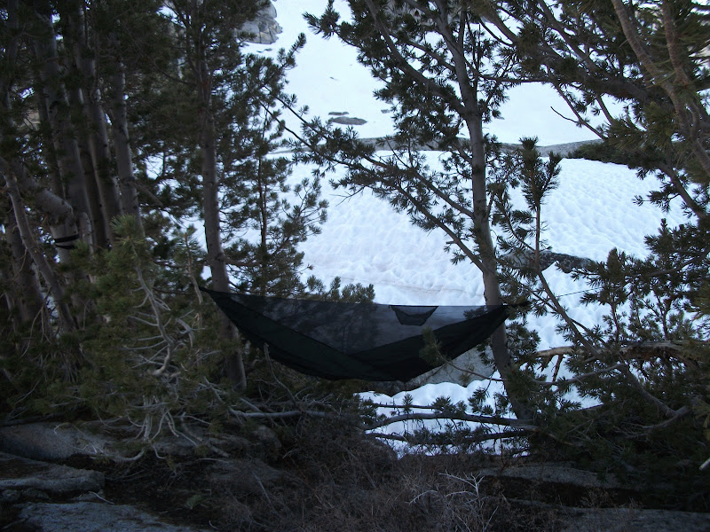
I met a few people on the way up to the pass, and eventually caught up with Sly. We went together over Kearsarge Pass and, despite the light starting to fade, we went over Glen Pass as well. There was rather fun log crossing between two lakes, and then Sly kind of took off. He was certainly more acclimatized to the altitude than me and the week that I took off probably didn't help me either. I found a campsite and put my hammock up above some snow.
The next day I was not planning to go far, and at least that much went as planned. Right from the start, I had to cross a creek. Without the practice that I would later acquire, and all by myself, I didn't really know what to do. I dilly-dallied around a bit, changed into camp shoes, and finally did what I should have done in the first place: just crossed. I was spending a lot of time looking for the trail, but I could tell that I was going in the correct general direction because there was a river that I was following down hill.
Eventually, I came to a tributary and was stuck once again. The tributary was mainly shallow, but had a main channel about three or four feet wide that just seemed impassible. I went up and down it, looking for a place to cross. I must have spent an hour looking for a place where the main channel was a little shallower. Once again, though, I simply crossed where the creek crossed the trail. The water came up to my mid-thigh and I later learned that people had fallen in this creek and lost poles and things. I was getting a little freaked-out at this point, because I was on the wrong side of a roaring river and the map didn't show any bridge. Also, I had only gone a few miles and it was getting toward lunch time.
I continued on down the hill until I did come to a bridge. I was extremely glad to see it, since it was just below the confluence of two rivers that could hardly have been more full. I could really see that water was going to be the problem this section. I had lunch and then started up hill. There was a pass ahead, and I was fairly sure that I wouldn't make it that evening, but I was hoping to get as high as possible. I was still pretty tired, though, and only made it a few more miles before camping on the side of a hill.
More passes and a new group
As I was cooking dinner sitting on the trail, a group of people came by. I had been hoping to find some more people so that we could all look out for each other in the rivers. I asked if they would be okay with me tagging along and they said yes. They were going to walk a bit farther that evening, so I would have to catch up with them the next day. The cast of characters that I would be hanging out with for the next couple of weeks would be Ninja, Drop-n-Roll, K-bomb, and Roadrunner.
The next morning I got up early to try to catch up with them. Pinchot pass was ahead, so that meant that I was both climbing around 2000 feet in three miles and trying to catch up. I saw the group as they went over the pass, but I must have still been a half mile behind. Pinchot Pass was not too hard and before long I was over it. However, I was still pretty far behind and trying to catch up. At some point I lost the group's footprints and it was just me and my map. There were a couple of creeks that were pretty scary at the time, but turned out not to be too hard relatively speaking, but eventually I came out of the forest and found the group sitting and having lunch. We decided to go over Mather Pass that afternoon. I had heard Mather referred to as "Mather-fucker" the day before, so I was a little worried, but staying with the group that I had just caught was the priority.
We climbed another 2000 feet to Mather. It didn't look too bad. The most worrying aspect was that a few hundred feet below the pass was a lake with thin ice, so a fall would make you really cold. The trail officially went to the right around the lake, but there were footprints in the snow going to the left, so we followed those. We went straight up and eventually found ourselves on some rocks. These were actually much worse than the snow since there wasn't a real path on them. Ice axes also don't work on rock. While most of the rest of the group found a high route, I took the lower route. This allowed me to get back on the snow quicker, and I overtook them on the way to the pass. At the pass itself, the snow was corniced, meaning that wind had blown over the pass so it looked like a cresting wave coming towards us. I heard that it actually avalanched later in the season; I'm glad I wasn't there for that. In all, Mather was probably my second-least favorite pass.
We descended from Mather toward the Palisade Lakes. We had hoped to make it down to dry land, but the sun went down too quickly. The rest of the group slept on a big rock, while I was able to find two trees that had somehow gotten their roots through the rock. They were probably the only two trees that I could have used for hamocking for a couple of miles, so I felt pretty lucky to have a comfortable place to sleep.
The next day was quite long. We started by descending the so-called "Golden Staircase". Without snow, it's a beautiful set of stone steps next to a pretty creek. With snow, the steps are a bit harder to navigate. We left the snow again at the bottom and walked along Palisade Creek. At the bottom we got to 8000 feet of elevation. Our destination was Muir Pass at 12000 feet. There's not much to say about the rest of that day. It was beautiful but not particularly challenging. The pass had an obvious route up which was safe, and then at the top of the pass was Muir hut.
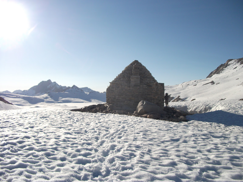
Muir hut is a stone structure built in the memory of John Muir. It's officially for hikers stranded because of weather and not supposed to be used for overnight stays, but the sun was going down and there was nothing but soft (i.e. hard-to-walk-on) snow for miles, so we stayed there.
The next morning, the snow was firm again, so we made good time. We were walking toward Evolution Creek, which the maps warn "can be a difficult ford". When we got there, it was up above my belly-button. It was quite cold, but it wasn't the raging cataracts that I had seen the previous few days, so I just did it. The five of us sat and ate lunch on the side of the river and dried our clothes. As we were eating, we saw a deer swim across the creek.
After Evolution Creek, the next really interesting crossing was a couple of days (and passes) later at Bear Creek. That did have both very high water and very fast water. We really should have crossed it as a group, but instead we chose to do it one at a time. At one point my foot slipped and I put my hand down on the bottom, but I was able to recover quickly enough that I didn't get swept away. Ninja was the last to cross Bear Creek and had the most trouble. The three guys (K-bomb, Roadrunner, and myself) got back in the water and made a little phalanx so that she could be shielded at least a little bit from the oncoming water. I was glad when we were across.
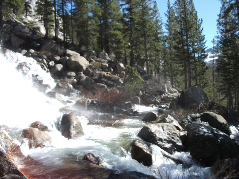
We had been thinking about stopping in at Vermillion Valley Ranch (VVR) the next day for some rest and supplies, but knew that it would be expensive if we did. We were running out of food and supplies and Mammoth was only a couple of days away. When we got there, we decided that we could make it to Mammoth. Almost as soon as we passed the cutoff trail for VVR, we ran into Mono Creek. We would have to cross it three times. The first time, we found a log. That's never really fun, but at least we stayed dry. The following time, we were in up to our thighs. Our final crossing was through what essentially a waterfall. The trail was well-made so that the crossing was not too dangerous, but it sure was impressive.
The following day, I left lunch a bit earlier than the rest of the group and got lost at least three times. It was getting dark by the time I found their campsite. It rained that night and snowed the next morning, but we were going to town, so we all felt pretty good.
We got lost on the side of a hill and started going up and down looking for the trail. A hiker from a different group finally found us and even threw us all a mini Snickers bar as we made it to the trail. We followed him all the way to the bus that took us Mammoth.
We spent two nights in Mammoth, even renting a cabin for the second night. I had an infection, so I went to the hospital to get it taken care of. Thankfully I had gotten insurance before leaving, so it didn't completely bankrupt me.
When we hit the trail again, we were well-rested and had another member of our group: Moccasin. He had been in Florida looking after his father for around a month, so he was not acclimatized to the altitude. Our first day back, we didn't go very far and he did okay, but the second day he had real trouble. We ate lunch at the top of Donohue Pass and his altitude sickness made him unable to eat for about two hours. Eventually he told us to go on without him and that he would catch up. We didn't want to, but we finally did. We had crossed paths with another group (Liz, Skinny D, Meow-Meow, and Funyan), which I would later join. They caught up with Moccasin and would give us a hard time about leaving him alone, and they were probably right. In any case, he made it down from the pass okay, and we all made camp in Lyell Canyon. We were going into Yosemite Valley the next day, excited about another taste of civilization after so short a time.
Next Time
Yosemite, and even harder river crossings.