As I mentioned in my last entry, Pennsylvania is many hikers' least-favorite state on the trail. This comes down to one thing: rocks. All the states have some rocks, but in Pennsylvania, they are relentless. They tend to be small, firmly stuck into the earth, and just the right shape for turning your ankle or at least moving your foot in your shoe. Since we were regularly doing 20-mile days by this point in the trail, we saw a lot of rocks every day.
Delaware Water Gap to Palmerton
Delaware Water Gap is named because it is a gap in the ridge caused by the Delaware River. It has a quaint little town, and we stopped in to get some pie and do a little shopping (I needed to replace my water bag, which had sprung a leak in New York). We didn't stay in town for the night, though, and went to a shelter with a nice view from the ridge.
The next day, we walked along the flat ridge all the way to the next gap, called Wind Gap, where we hitched into town for the night. Watching CNN, we learned that there were forest fires in Colorado, right near where Just Jill lived. Since only about 90 houses were burned down, I thought the probability of her being affected was pretty small, but I hoped that she wasn't nonetheless.
Wind Gap was one of the least hiker-friendly towns that we stayed in. As a hiker, you pretty much have to walk everywhere, so it is good if the town is very small and compact. Wind Gap was not compact, and it also had no sidewalks. When we went to get groceries, we had to cross a very large road, and people were honking their horns at us as if the lack of proper signals in the town was our fault. All in all, it wasn't a great town, and I wouldn't recommend that other hikers stay there.
We climbed up from the gap the next day and found Just Jill in a clearing at the top, putting away her tent. Her house had indeed burned down in the fires. Unfortunately, that meant the end of the trail for her. Most importantly, her boyfriend and dog were okay, and she was flying out to Colorado to meet them.
There was really nothing that we could do, so we kept on walking. Near the end of the day, we came to one of the most environmentally degraded areas of the trail: the Palmerton Superfund site. After months of mostly walking in forests, this was a completely bare ridge devoid of all trees. The lack of trees was apparently a result of the zinc-smelting industry in the town poisoning the soil with its emissions. It didn't bother me too much, but Picker especially thought it was creepy, and so we hustled through the deforested area.
However, before we could make it completely past the deforestation, we needed to descend into Lehigh Gap. This was one of the hardest descents we had since the White Mountains. I was glad to get to the bottom of the descent, but it just meant that we had to up to the next ridge. We saw two snakes at the shelter that we stayed at that night – mice are attracted by the crumbs hikers leave behind and snakes are attracted by the mice – so it was a bit hard to get to sleep, and I checked my shoes pretty carefully when I got out of my hammock the next night.
Palmerton to Duncannon
The hiking in this section was honestly not that interesting. The ridges were flat and rocky, and we simply tried to pass the time and make miles.
After Wind Gap, we stayed in Port Clinton, where we went to the world's largest Cabela's. They actually picked us up and drove us to the store. It is supposed to be an outdoors store, but it is more of a hunting and fishing store, so we didn't find too much to interest us. However, they did have an all-you-can-eat buffet, so we gorged ourselves a bit. The next day was the first day of the NCAA football season, and Picker was a die-hard University of Miami fan, so we needed to get to town and find a hotel with ESPN. The only town that we thought we could get to was Shartlesville, which is marked in the guide book, but which is only accessible from the trail via a dirt road. Since there was no possibility of a hitch (and the football game was so crucial to see), we walked the nearly 4 miles to town. It turned out to be little more than a rest-stop on the interstate, but we found a hotel with cable and checked in.
Miami lost, and the next day it was lightly raining. So we decided to take a zero (my first since Vermont) and stay in the hotel.
We walked back to the trail the next day (walking off-trail is never fun for me) and continued on. I really don't remember much of the next few days. I can guarantee you that there were rocks. Eventually, we crossed the Susquehanna River and walked into Duncannon.
Duncannon is one of the most popular towns on the trail. It has a cheap hole-in-the-wall hotel with decent food and good beer where all hikers stay. I met up with my uncle there and we had a very nice supper. The next day was drizzling again, and again we decided that we would rather not walk in the rain, so we took another zero. Since my uncle had paid for our rooms the previous night (unbeknownst to me), we felt that we would not be breaking the bank by doing this.
However, the next day, we felt that we had some miles to make up. We had planned to make it to Boiling Springs in two days from Duncannon, but we did it in one day instead. Grinner wasn't too happy about going 26 miles, but the terrain was pretty flat and we crossed a road every mile or two, so it was pretty easy to keep track of how far we needed to go. Plus, we had mostly gotten rid of the rocks that had been plaguing us, so we could walk a bit faster.
Midpoint to Border
Late the next day, we hit Pine Grove Furnace State Park. It's a really nice State Park, but it has the feature of having the nearest convenience store to the midpoint of the trail. There's a tradition known as the Half-Gallon Challenge that occurs there. Since you've come halfway, you must eat a half-gallon of ice cream in under an hour.
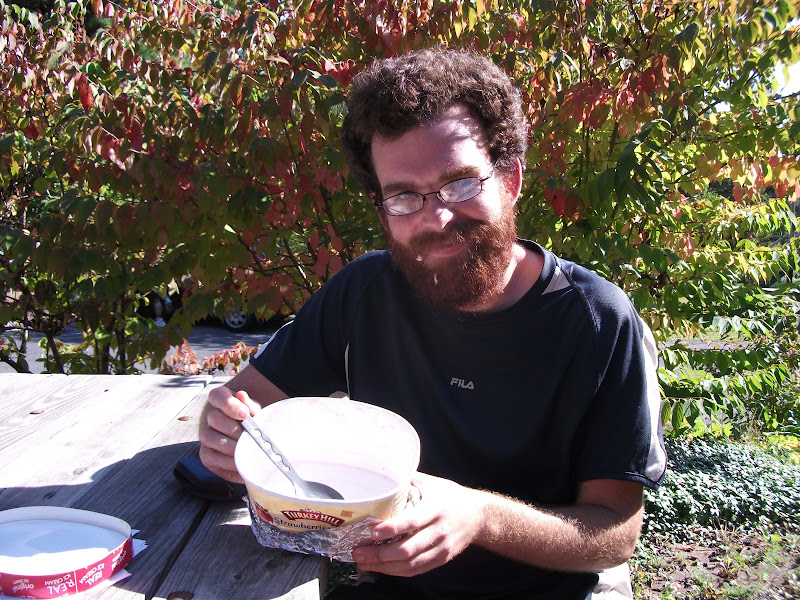
As you can see, I left a little bit in my beard, but I finished it with plenty of time to spare. Picker finished his half-gallon a bit faster than me, but Grinner didn't quite make it – she left about three bites.
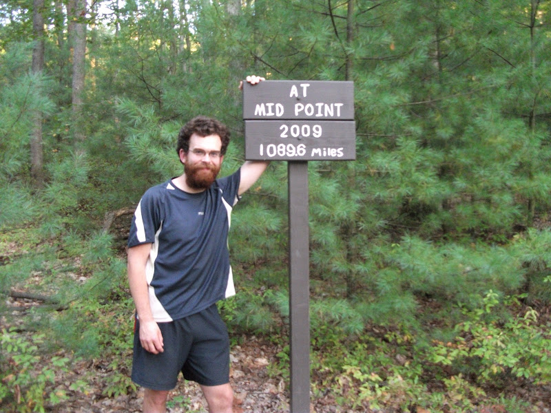
None of us felt wonderful after consuming that much ice cream, so we didn't go much farther that night. The next morning, however, we hit the midpoint of the trail.
Around this time, the oak trees were shedding their acorns, so as we walked, we would hear the acorns hitting the ground. Occasionally someone would get hit by one. They were pretty big acorns, so they would hurt and leave a bruise. At our campsite for that night, there was a large group of birds in the trees above us. They shook the branches even more than usual, so we had a veritable hailstorm of acorns.
We went into Waynesboro, PA the next day and I bought new shoes (my previous pair lasting nearly 800 miles). We also had a Chinese buffet. Somewhere in the previous few days I had lost my trowel, so I went to a garden store and got a new one. (I never used a trowel all that much because I usually stayed near a shelter and most shelters have privies, but it is important to have one for emergencies.) We resupplied in town and walked on for a couple of miles to a campsite just before the border.
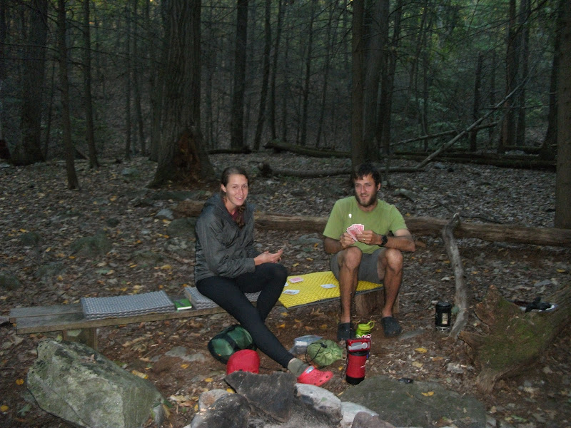
I had a plan for a crazy amount of miles the next day, so it was to be my last day with Picker and Grinner. We had walked with each other for nearly 1000 miles, so I was sorry to leave them. I took a picture of our campsite, with them doing a fairly typical activity: playing rummy.
Next time
The day with the crazy mileage, taking me into Virginia. Since Virginia is the longest state on the trail (nearly a third of the miles), I'm sure I won't be able to write the whole thing in one entry.